Milestones on the B4215
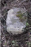
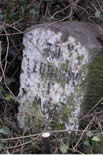
This route continues the stone format of the Gloucester to Newent route – simple lettering in limestone. The length of the one lying down being a metre, and still having some in the ground, shows how much stone was needed for a relatively simple marker, and either how much the others have sunk or how the verge has been built up.
The turnpike date for this route is 1768. The first four stones out of Newent were not found.
| OS / Location | Dimensions | Image | Notes / Comments |
| SO703334 Greenway Left MS |
1000x32x20 |  |
TO LEDBURY 3 MILES NEWENT 5 MILESWhite with black lettering Lying down Limestone |
| SO707349 Left MS |
55x31x23 |  |
TO LEDBURY 2 MILES NEWENT 6 MILESWhite with black lettering Sunk Limestone |
| SO705376 Hazle FarmLeft MS |
56x31x23 |  |
TO LEDBURY 1 MILE NEWENT 7 MILESWhite with black lettering Sunk Limestone |
